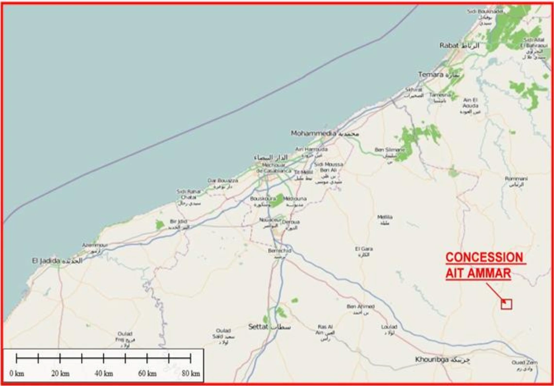
Ait Ammar is a mining concession with resources of iron ore. This mine is located 150 km east of the city of Casablanca. It is Connected by railway & road to most of the major ports of Morocco.
The CMMF (COMPAGNIE MAROCAINE MINIERE DE FER) is a Moroccan company, created in 2011, which exploits the iron deposit of the AIT AMMAR mine, for which it benefits from a lease contract from ONHYM.
Geo-location: 33° 3'58.55"N, 6°38'57.75"W

From 1932 to 1962 the Iron ore of Ait Ammar was extracted and commercialized lately by French company (SMMPC).
From 1962 to 1983, the Bureau of research and mining exploitation (BRPM which is now the National Office of Hydrocarbons and mines ONHYM), conducted several survey drillings to evaluate the resources and increase the reserves. Also, several laboratory studies and test pilots were performed to identify the best possible beneficiation methods. And finally, a financial and technical feasibility study was also carried out.
From 1932 to 1962, production reached 6 million. This figure is unofficial as there are no documents showing the details. The extraction was both in open pit and underground methods. Ait Ammar mine was closed in 1962. for various reasons, including the structurally low iron prices at the time and the expensive exploitation techniques of the time which did not allow for satisfactory economic profitability. After being leased by CMMF in 2011, the company made a pre-feasibility study which showed low financial margines. However, this company steadily reviewed market for a reliable condition for continuation of investment in this project. Mainly after the Covid pandemic (ended in mid-2023), a new phase of studies started by finding some of the important mission geological data from previous borehole drillings (back to 1960s). By good signs from the global market since mid-2023, CMMF established a core team of experts in its central office and shortly in a few months a site-based team started mobilization, field works and operational activities in the second half of 2024.
The mine is located on the south side of a large lower Paleozoic syncline with NE-SW trend. The syncline is composed of a series of Siluro-Ordovician schists in which, two Oolite Iron oxide layers, 3km long, are inserted flushing with surface. The thickness of these mineralized layers varies from around 30cm to 30 meters. The ore is essentially composed of magnetite, chamosite, siderose, apatite and quart.
This region had been under several phases of prospecting (such as aerial magnetometry) and exploration (mainly borehole drilling). Most of them date back to 1960s. Some of the data is missing during decades of inactivity. In 1965 and 1983 in two different studies at least 110 boreholes (mostly diamond core) are drilled. BRPM reported the proven resource 86 and 69.318 million tons respectively. These estimations were by old methods without geostatistical methods and the currently available software packages. In 2014 made a new estimate of 89 million tons with an average 44% Fe. In late 2023 as CMMF established a new management and core team of mining experts, by reviewing and rectifying old paper-based maps or log-sheets, the content of borehole databased increased significantly as summarized in the below table. These newly found boreholes data are validated and approved in late 2024 when the site-team managed to measure many of the borehole’s collars.
However, and as still many of the data and all the core boxes are missing, CMMF plans to conduct in-fill drilling campaign with priorities of plant construction and mid-term production.


